Landscape and rivers
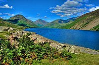
Geographically England comprises the central and southern two-thirds of the island of Great Britain, plus such offshore islands as the Isle of Wight and the Isles of Scilly. It is bordered by two fellow countries of the United Kingdom—to the north by Scotland and to the west by Wales. England is closer to the European Continent than any other part of mainland Britain. It is separated from France by a 34-kilometre (21 mi) sea gap, though the two countries are connected by the Channel Tunnel near Folkestone.[94][95] As England is on an island, is it surrounded by the water of the Irish Sea, North Sea and Atlantic Ocean. The most important rivers in England, because of their ports of London, Liverpool, and Newcastle, are the tidal rivers Thames, Mersey and Tyne. The tides raise the level of water in their estuaries and enable ships to enter the ports. At 354 kilometres (220 mi), the Severn is the longest river flowing through England. It empties into the Bristol Channel and is notable for its Severn Bore tidal waves, which can reach 2 metres (6.6 ft) in height.However, the longest river entirely in England is the Thames, which is 346 kilometres (215 mi) in length.There are many lakes in England but the majority are in the aptly named Lake District; the largest of which is Lake Windermere, it is known by the nickname "Queen of Lakes".
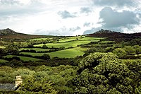
The Pennines, known as the backbone of England, is the oldest mountain range in the country, originating from the end of the Paleozoic Era around 300 million years ago. The total length of the Pennines is 400 kilometres (250 mi), peaking at Cross Fell in Cumbria.The material of which they are composed is mostly sandstone and limestone, but also coal. There are karst landscapes in calcite areas such as parts of Yorkshire and Derbyshire. The Pennine landscape is high moorland in upland areas, indented by fertile valleys of the region's rivers. They contain three national parks, the Yorkshire Dales, Northumberland, and the Peak District. The highest point in England, at 978 metres (3,210 ft), is Scafell Pike in Cumbria. Straddling the border between England and Scotland are the Cheviot Hills. The English Lowlands are to the south of the Pennines, consisting of green rolling hills, including the Cotswold Hills, Chiltern Hills, North and South Downs—where they meet the sea they form white rock exposures such as the cliffs of Dover. The granitic Southwest Peninsula in the West Country provides upland moorland, such as Dartmoor and Exmoor, which flourish with a mild climate; both are national parks.
Climate
England has a temperate maritime climate meaning that it is mild with temperatures not much lower than 0 °C (32 °F) in winter and not much higher than 32 °C (90 °F) in summer. The weather is damp relatively frequently and is subject to change. The coldest months are January and February, the latter particularly on the English coast, while July is normally the warmest month. Months with mild to warm weather with least rainfall are May, June, September and October. The biggest influences on the climate of England comes from the proximity to the Atlantic Ocean, its northern latitude and warming of the waters around the Gulf Stream. England receives quite a significant proportion of rainfall during the year, with autumn and winter being the wettest time—geographically the Lake District receives more rain than anywhere else in the country. Since weather recording records began, the highest temperature received was 38.5 °C (101.3 °F) on 10 August 2003 at Brogdale in Kent, while the lowest was −26.1 °C (−15 °F) on 10 January 1982 in Edgmond, Shropshire.
| [hide]Weather data for England | |||||||||||||
|---|---|---|---|---|---|---|---|---|---|---|---|---|---|
| Month | Jan | Feb | Mar | Apr | May | Jun | Jul | Aug | Sep | Oct | Nov | Dec | Year |
| Average high °C (°F) | 7 (45) | 7 (45) | 9 (48) | 12 (54) | 15 (59) | 18 (64) | 21 (70) | 21 (70) | 18 (64) | 14 (57) | 10 (50) | 7 (45) | 13 (55) |
| Average low °C (°F) | 1 (34) | 1 (34) | 2 (36) | 4 (39) | 6 (43) | 9 (48) | 11 (52) | 11 (52) | 9 (48) | 7 (45) | 4 (39) | 2 (36) | 6 (43) |
| Precipitation mm (inches) | 84 (3.31) | 60 (2.36) | 67 (2.64) | 57 (2.24) | 56 (2.2) | 63 (2.48) | 54 (2.13) | 67 (2.64) | 73 (2.87) | 84 (3.31) | 84 (3.31) | 90 (3.54) | 838 (32.99) |
| Source: Met Office[102] 19 February 2008 | |||||||||||||
Major conurbations
The Greater London Urban Area is by far the largest metropolitan area in England and one of the busiest cities in the world. It is considered a global city and has a population larger than other countries in the United Kingdom besides England itself. Other urban areas of considerable size and influence tend to be in northern England or the English Midlands. There are fifty settlements which have been designated city status in England, while the wider United Kingdom has sixty-six. While many cities in England are quite large in size, such as Birmingham, Manchester, Liverpool, Leeds, Newcastle, Bradford, Nottingham and others, a large population is not necessarily a prerequisite for a settlement to be afforded city status.[104] Traditionally the status was afforded to towns with diocesan cathedrals and so there are smaller cities like Wells, Ely, Ripon, Truro and Chichester. According to the Office for National Statistics the ten largest, continuous built-up urban areas

No comments:
Post a Comment